
Mumbai Coastal Road Project 2024- Opening date, cost, benefits, routes and more
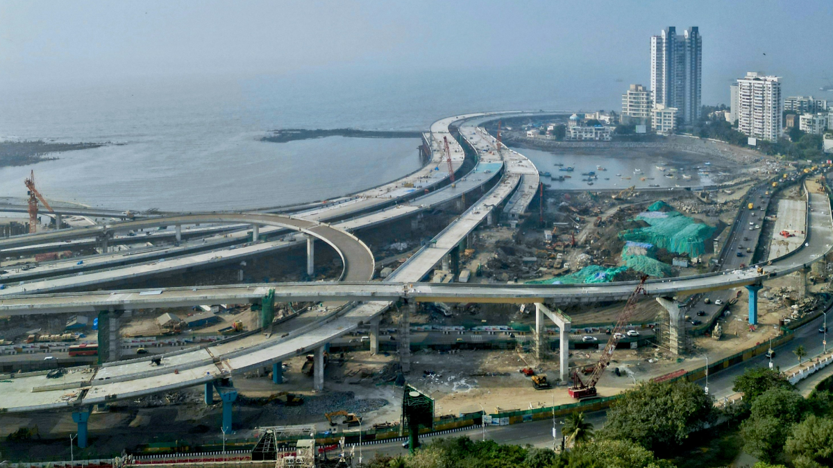
Coastal Road formally known as Chhatrapati Sambhaji Maharaj Coastal Motorway, is a grade separated highway with eight lanes and a length of 29.2 km. It is currently under construction and will connect Kandivali in the north to Marine Lines in the south along Mumbai's western shore. The estimated daily usage of 130,000 vehicles is anticipated to result in a 2-hour reduction in travel time between South Mumbai and the Western Suburbs to just 40 minutes. ₹13,060 crore, or US$1.6 billion, is the project's anticipated cost. The 10.58 km first phase of the project is now being built, and it runs from the Princess Street flyover to the Worli end of the Bandra-Worli Sea Link.
The main aim of the coastal road project is to ease the traffic of south Mumbai during the morning and evening peak hours. Thus, it has been designed to make connectivity better between the southern and northern parts of the city. Authorities expect that with this mega project, Mumbaikars will certainly save at least 70 per cent of their commute time and it will also help lower fuel consumption by 30-34 per cent. Currently, due to traffic congestion during morning and evening peak hours, it takes 30-40 minutes to travel between Worli and Marine Drive. But authorities are confident that with the help of the coastal road project, the travel time will significantly be reduced to 10-12 minutes.
.png)
Phase 1: Bridging the South (Princess Flyover Road - Worli Sea Link)
10.5 km of seamless travel: This completed section already eases commutes, connecting south Mumbai with the iconic Worli Sea Link.
Double the lanes, double the efficiency: Eight dedicated lanes (four northbound, four southbound) ensure smooth traffic flow, with an additional lane dedicated to public buses for greener commutes.
Plunging beneath the waves: A groundbreaking feat, the project boasts the country's first undersea tunnels, twin arteries stretching 2.07 km at depths of 7-20 meters below the Arabian Sea.
Beyond cars: Encouraging pedestrian and public transport, Phase 1 features 10 bus bays, three underground parking lots for 1,800 cars, and 16 pedestrian underpasses for enhanced connectivity.
.png)
Phase 2: Extending the Reach (Versova - Dahisar)
Connecting the west and north: This ambitious phase, currently in its initial stages, aims to extend the coastal artery from Versova in the western suburbs to Dahisar in the north.
Six packages, one vision: The project is divided into six distinct packages for efficient construction. Each focus on specific stretches, like the 4.5 km from Versova to Bangur Nagar or the 3.66 km north and south-bound connections between Mindspace and Charkop.
Expanding the footprint: The project doesn't stop at Dahisar. Package E envisions a 3.78 km connection to Gorai, while Package F bridges the remaining 3.69 km to Dahisar, creating a truly comprehensive coastal route.
Phase One Opening Date of coastal road project:
Prime Minister Narendra Modi will be inaugurating the Mumbai Coastal Road Project (MCRP) on February 19, 2024, which has been named after the legendary Maratha warrior’s son Chhatrapati Sambhaji Maharaj, coinciding with his birth anniversary, BMC’s Municipal Commissioner and Administrator Dr Iqbal Singh Chahal confirmed.
The one-of-its-kind project in India is being executed by the Brihanmumbai Municipal Corporation (BMC).
The road will improve connectivity between different city parts and boost economic activity
Coastal road's speed restrictions
The coastal road's speed restriction has been maintained at 80 kmph with an emphasis on safety. Reducing traffic is expected to lessen air pollution and noise, which would further enhance the city's air quality, according to the BMC. The initiative is also anticipated by the civic body to result in a notable decrease in carbon impact.
Coastal Road's Reduced travel time
One of the key goals of this project is to reduce the terrible traffic congestion that has become a daily occurrence for Mumbai residents. While the current road network is large, it struggles to keep up with the city's ever-increasing traffic. As a result, everyday journeys are frequently time-consuming and irritating, with jam traffic becoming prevalent during peak hours. According to BMC estimates, the coastal road would cut travel time between Princess Street and BWSL to less than 10 minutes, a significant reduction over the existing 35-45 minutes during peak hours.
Coastal Road's Eco-Friendly Boon (Fuel saving)
Beyond saving precious time and easing commutes, the Mumbai Coastal Road Project boasts a powerful environmental benefit: a projected 35% reduction in fuel consumption. Say goodbye to idling at red lights and hello to cleaner air! This translates to less greenhouse gas emissions, a healthier city, and a positive step towards sustainable urban development. The Coastal Road isn't just a path to faster commutes, it's a path towards a greener future for Mumbai.
Mumbai's Coastal Road promises not just a scenic drive within the city but also a seamless connection to other parts of India. Imagine arriving by train at a nearby station and easily transitioning to a coastal adventure with the help of Yatri App, your virtual travel companion.
Beyond the Road Yatri integrates with public transport options, suggesting nearby stations and ferry services, making your coastal exploration truly multimodal and sustainable
Nearby Railway Stations:
- Churchgate: Reached by M.L. Sahukar Marg and Swami Vivekanand Road, about 2.5 km south of Princess Flyover. provides a wide range of facilities, including restrooms, waiting areas, snack stands, ATMs, elevators, and escalators.
- Marine Lines: Through M.L. Sahukar Marg., approximately 2.8 km south of Princess Flyover. provide necessities such as restrooms, waiting areas, snack stands, and cash machines.
- Charni Road: Take M.L. Sahukar Marg and D.N. Road for approximately 3.5 km south of Princess Flyover. offers Churchgate station-like facilities.
- Grant Road: accessible by M.L. Sahukar Marg and D.N. Road, approximately 4 km south of Princess Flyover. offers standard facilities, such as snack stands, restrooms, and waiting areas.
Yatri App and Station Amenities:
With Yatri App, you can easily access information about these stations' amenities:
- Open the Yatri App: Search for any of the mentioned stations (e.g., "Churchgate Station").
- Tap on the Station Name: See details like arrival/departure timings, platform information, and fares.
- Swipe Up: You'll find the "Station Amenities" section with details about:
- Essential Facilities: Toilets, waiting rooms, cloakrooms, ATMs, etc.
- Food and Beverage: Food stalls, restaurants, convenience stores, etc.
- Accessibility: Lifts, ramps, designated areas for differently-abled passengers, etc.
- Other Services: Booking platforms for taxis, buses, or car rentals, etc.
Dated February 8, 2024